मॅप्स एक क्षेत्र की कहानी और इतिहास को दर्शाता है| और यह आपका हक है की आप अपने क्षेत्र की भाषा में मॅप्स का उपयोग कर सकें| आप मपज़ें और टांगराम के ज़रिए हिन्दी और भारत की अन्य भाषाओ में मॅप्स की रचना कर सकते हैं|
মানচিত্র আমাদের ইতিহাস এবং গল্পের ছিন্নো. আর মানচিত্র নিজেদের ভাসএ ব্যাবহার করার অধিকার আপনার সবার. MAPZEN আর TANGRAM ব্যাবহার করে বাংলএ এবং অনন্যও ভারতীয়ো ভাসএ মানচিত্র সৃষ্টি করতে পারেন.
.مپس ایک علاقے کی کہانی اور تاریخ کی عکاسی کرتا ہے. اور یہ آپ حق ہے کے آپ اپنے علاقے کی زبان میں مپس کو استعمال کر سکیں. آپ مپذے اور ٹاگرام کے ذریعہ ہندی اور ہندوستان کی دیگر بھاشاو میں مپس کی تحریر کر سکتے ہیں
ನಕ್ಷೆಗಳು ಪ್ರಾದೇಶಿಕ ಹಾಗೂ ಇತಿಹಾಸ ಕತೆಗಳ ಸಂಕೇತವಾಗಿದೆ. ನಿಮ್ಮ ಮಾತೃ ಭಾಷೆಯಲ್ಲಿ ನಕ್ಷೆಗಳನ್ನು ಉಪಯೋಗಿಸುವ ಹಕ್ಕು ನಿಮ್ಮದಾಗಿದೆ. ನಿಮ್ಮ ಭಾಷೆಯಲ್ಲಿ ನಕ್ಷೆಗಳನ್ನು ಸೃಷ್ಟಿ ಮಾಡಲು ಮ್ಯಾಪ್ಜ಼ೆನ್ ಮತ್ತು ಟ್ಯಾನ್ ಗ್ರಾಮನ್ನು ಬಳಕೆ ಮಾಡಬಹುದಾಗಿದೆ.
As we note in Hindi, Bengali, Urdu and Kannada above, maps tell the story of a region, and at Mapzen we think you should be able to tell these stories in your own language. Wherever you live, you can use Mapzen and Tangram to localize your maps.
India has many stories to tell, from the mythological world to years of dynastic and colonial rule. Each time that lines on the maps move, there is a new story to tell, even today.
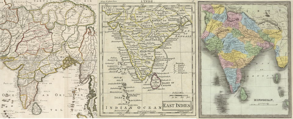
Images via David Rumsey. Left: l'Inde deca et dela le Gange, ou est l'Empire du Grand Mogul, and Partie Meridionale de l'Inde En deux Presque Isles l'vne de ca et l'autre de la le Gange(Nicolas and Guillaume Sanson, 1697/1703/1709). Center: A New General and Universal Atlas Containing Forty five Maps By Andrew Dury (Andrew Dury, 1763). Right: Hindostan, p. 106 from A New Universal Atlas; Comprising Separate Maps Of all the Principal Empires, Kingdoms & States Throughout the World (David Burr & Thomas Illman, 1835)
In 2014, India’s Commissioner for Linguistic Minorities talked about the ties between language and culture:
India, one of the world’s ancient civilizations, puts forth a magnificent mosaic of multiple castes, religions and languages. Our centuries-old multilingual, multicultural ethos has held the country together like the thread in the rosary of beads, representing ‘unity in diversity’ in our country.
There are 23 official languages in India (including English). According to the 2001 Census language statistics (the 2011 Census language data is not yet available). While Hindi and Bengali are the most widely spoken languages, other languages are the majority in many Indian states.
| Language | Native Speakers | Majority States |
|---|---|---|
| Hindi | 422 million | 10 |
| Bengali | 83 million | 7 |
| Telugu | 74 million | 1 |
| Marathi | 72 million | 1 |
| Tamil | 60 million | 2 |
| Urdu | 52 million | 0 |
| Gujarati | 46 million | 2 |
| Kannada | 37 million | 1 |
Below is a map of Indian states, with the name in the majority language.
The number of people in each Indian state rivals that of many nations. Population data is available in the Mapzen gazetteer Who’s On First, and by exporting the states of India as a GeoJSON feature collection we were able to import it into Tangram and display it below the native language names, along with a greyscale choropleth and a dynamic comparison to the population of a certain “large” American state.
(Note that we are overlaying the state boundaries and labels on the Mapzen house style, Refill. While we could have picked the no-labels version, we chose to fade out Refill’s labels. This way, cities are still visible for context in the greyscale choropleth style, but the state names and data we are displaying have priority. You can see what’s happening behind the scenes in Tangram Play. If you want to make your own population comparison, change global.population and global.compare_nation. You can also pick a variety of base colors for the choropleth by altering choropleth_color in the global variable section.)
Users around the world have added hundreds of languages with different scripts to places in OpenStreetMap. The Tangram mapping engine is flexible enough to support most of these, including those that render with text shaping and text positioning, such as हिन्दी (Hindi), ಕನ್ನಡ (Kannada), தமிழ் (Tamil), ગુજરાતી (Gujarati), and తెలుగు (Telugu). It can also properly display right-to-left languages like اردو (Urdu) (which is also rendered with text shaping and positioning).
Our browser-based Tangram JS renderer utilizes Canvas to render these scripts. The Tangram ES native renderer uses Alfons, an amalgamation of some very useful open-source text rendering libraries like HarfBuzz, Freetype, and ICU to serve vertices and glyph textures for our OpenGL renderer.
But how to access these languages? We are adding language flags to Mapzen in-house styles which will allow you to display your desired language with very little effort. It’s already available in Bubble Wrap (and is coming to the rest of our house styles soon!) Below you can see maps of Karnataka with text labels in Kannada.
To change the text, import the standard Bubble Wrap default scene file and modify the language global value to your preferred language code.
import: https://mapzen.com/carto/bubble-wrap-style/bubble-wrap.yaml

global:
    ux_language: kn
(The language value can also be changed via the Tangram JavaScript API.)
Where do these labels come from? We are able to show maps in Kannada because residents of Karnataka and native speakers of Kannada have been hard at work adding over 40,000 labels to nodes, ways and relations in OpenStreetMap.
Changing the two letter language code gets you a map of Maharashtra with Marathi labels:
import: https://mapzen.com/carto/bubble-wrap-style/bubble-wrap.yaml

global:
    ux_language: mr
While there are only 5,000 tags in Marathi, you can make this better in OpenStreetMap! Thejesh GN has been doing excellent work tracking the progress of Indian native language maps and has a tutorial on how to add translations to OSM.
Whether you speak one of India’s 22 official languages, or one of the hundreds of others spoken on the Indian subcontinent, or any other language in the world, add it to OpenStreetMap! Mapzen Vector Tiles are updated constantly, and any tags you add in your native language will show up quickly, usually within a day! Make your map tell a story in your mother tongue!
Disputed Territories between India and its neighbouring countries: The dashed lines in the map represent the disputed/claimed boundaries between India-Pakistan and India-China. The map is in accordance with the UN representation of the Indian border and the shape of the entire Indian map including the dashed lines is in accordance with Indian Law.

