Welcome to the Targeted Editing series where today you can kick back on your favorite sectional, or make OpenStreetMap data exceptional! (Both take about the same amount of time.)
May is National Bike Month in the United States, and bike to work and school activities are being hosted across the country. Are you a cycling commuter or aspire to be one? You are in good company!
Read on for some basic uses for tags commonly associated with bike maps, and how you can check to see if you can use your local knowledge to add features where they are needed.
How are bike paths and associated features used?
- Help with search. What kinds of things might bicyclists search for? Cyclists definitely search for routes that are safe but there are a lot of additional features that are equally important. Just a few examples include bicycle shops for supplies, bicycle repair stations, and definitely bicycle parking.
- Help with routing. Getting from point A to B via bicycle can incorporate road criteria that pedestrians and cars prioritize differently. The surface type of the road can be used to differentiate routes for different types of bicycles. Road types or road classes can be used to differentiate routes based on the experience level of the rider. Even the type of bicycle lane can make a huge difference in the desirability of a suggested route. Some bicycle lanes are protected, some are merely buffered from vehicle traffic, and others are completely separated, bypassing vehicle traffic all together.
- Help with map rendering. Bicycle features can be used to make custom maps designated specifically for bicycle commuters.
Are there bicycling features in OpenStreetMap? Yes!
A quick review of the data in some of our favorite bike friendly cities shows how promising it is in more detail:
Bicycle Features in OpenStreetMap
| Bike Tracks (km) | Bike Lanes (km) | Bike Route Relations (km) | Bike Points of Interest | |
|---|---|---|---|---|
| Amsterdam | 6,993 | 1,061 | 5,046 | 562 |
| Barcelona | 455 | 326 | 110 | 276 |
| Berlin | 4,338 | 3,207 | 14,320 | 1,032 |
| Buenos Aires | 148 | 204 | 294 | 115 |
| Chicago | 3,201 | 833 | 2,187 | 438 |
| Copenhagen | 5,381 | 2,983 | 3,411 | 684 |
| London | 3,831 | 2,149 | 9,147 | 1,166 |
| Minneapolis / St Paul | 1,733 | 731 | 2,159 | 218 |
| Montreal | 2,032 | 2,152 | 1,757 | 175 |
| New York City | 654 | 814 | 1,613 | 492 |
| Paris | 2,189 | 2,385 | 1,465 | 1,673 |
| Portland OR | 202 | 2,621 | 1,199 | 146 |
| San Francisco | 553 | 1,238 | 1,262 | 175 |
| Tucson | 241 | 156 | 505 | 25 |
| Washington DC | 2,519 | 1,100 | 1,722 | 337 |
For our table above, bike tracks are separate from the road or simply off-road, and bike lanes are part of the existing road. Some of them are part of bike route relations, but we would like to call those out separately. Bike points of interest includes bicycle parking, repair stations, rental locations and shops that specialize in bicycle merchandise.
Bicycle infrastructure is well represented in OpenStreetMap and there are lots of web maps that have been built to highlight these features. Here are just a few:
- Bike Citizens
- CycleStreets
- cycle.travel
- Global Bike Map built by Jens von Bergmann
- Hike & Bike Map
- OpenCycleMap
- OpenFietsmap
- OpenRouteService
- VeloMap
Let’s Get Mapping!
If you are a bicycle enthusiast you will find lots of tags in OpenStreetMap to support cycle life. Most of the popular tags are associated with the highway and cycleway keys, but other features associated with bike rentals, parking, and repairs are growing in numbers. Read on for some suggestions and links to their corresponding OpenStreetMap wiki pages.
Some OpenStreetMap conventions to keep in mind:
- Do not digitize separate features for bike lanes if they are part of a road with no separation from vehicular traffic.
- Designated Cycle Lanes tagged
cycleway=laneare on the existing road. - Shared Lanes tagged
cycleway=shared_lane,cycleway=shared_busway, or simplycycleway=sharedindicate shared cycle lanes. - Cycle Tracks running parallel to the road yet separated from cars by a physical barrier are tagged
highway=cyclewaywhen they are digitized as separate features.
Creating a great map for cyclists involves identifying preferred routes. When given the choice between riding a bike on a road with a designated bike lane vs a road without, most cyclists will choose the former. We’re not talking about the mighty few that live for the adrenaline of riding in full traffic. We know you are happy to ride just about anywhere. For the rest of us, a little protection goes a long way towards a comfortable safe ride.
In addition to features that support routing, there are also several points of interest that are particularly valuable to cyclists. Parking designated for bicycles and shops that specialize in bicycle related merchandise are just a few of the things that cyclists would love to see prominently featured on a map.
Cycle Based Characteristics
Have you ever had the pleasure of riding a bike on a designated bicycle route? There are some excellent routes that incorporate reclaimed rail corridors. The Midtown Greenway in Minneapolis is a great example. Since these routes were originally traversed by trains, they tend to be separate from vehicular traffic and gentle in grade. Perfect for pleasurable cycling!
If you are aware of a designated and often signposted bicycle route, check OpenStreetMap to see if it’s there. It will likely and should be represented as a relation.
There are several tags that enhance bike route relations. For example, make sure the bike route relation has a name so it can be search for, displayed, and incorporated into spoken and written turn by turn directions.
There are also different types of bike routes relative to the scope of the route. Is it a national, regional, or local bike route? Explore these cycle network tag options for national cycle networks, regional cycle networks, and local cycle networks:
Really, the more detail you can add, the better! All of these details can be incorporated into generating the best routes and beautifully detailed maps.
If you prefer routes that are designated solely for bicycles, tags make all the difference. Do you ride on a multi-use path that segregates bikes from pedestrians? Find it in OpenStreetMap and ensure that the bicycle=designated with segregated=yes tags are associated with the associated features tagged highway=path.
For multi-use paths, there are many additional combinations of tags to explore.
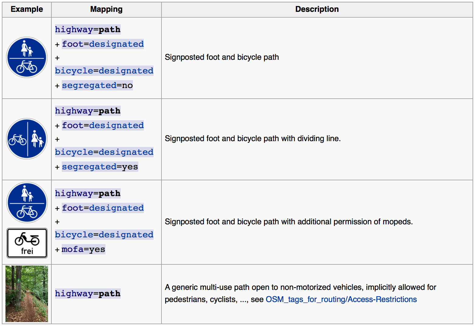 image via OSM wiki
Sure, there are often conventions for which side of the road to ride on relative to vehicle traffic, but sometimes a bike lane itself can be strictly designated oneway for bikes. Yes, it’s true! But how do you tag this so it’s relative to the bike lane, NOT vehicular traffic? This is where a subkey comes into play. A subkey is represented with a colon. It takes the form key:subkey=value, and in this case, the values are either yes or no.
Once this subkey is in place, the flow of traffic is relative to the direction in which the way was digitized. Luckily, the direction of the way can be selected and reversed. Just select the feature and look for this icon in iD: ![]()
Subkeys are also used to indicate which side of the road a cyclist can find a bike lane. These tags are particularly helpful when a lane is only present on one side. An example would be cycleway:right=lane paired with a highway tag.
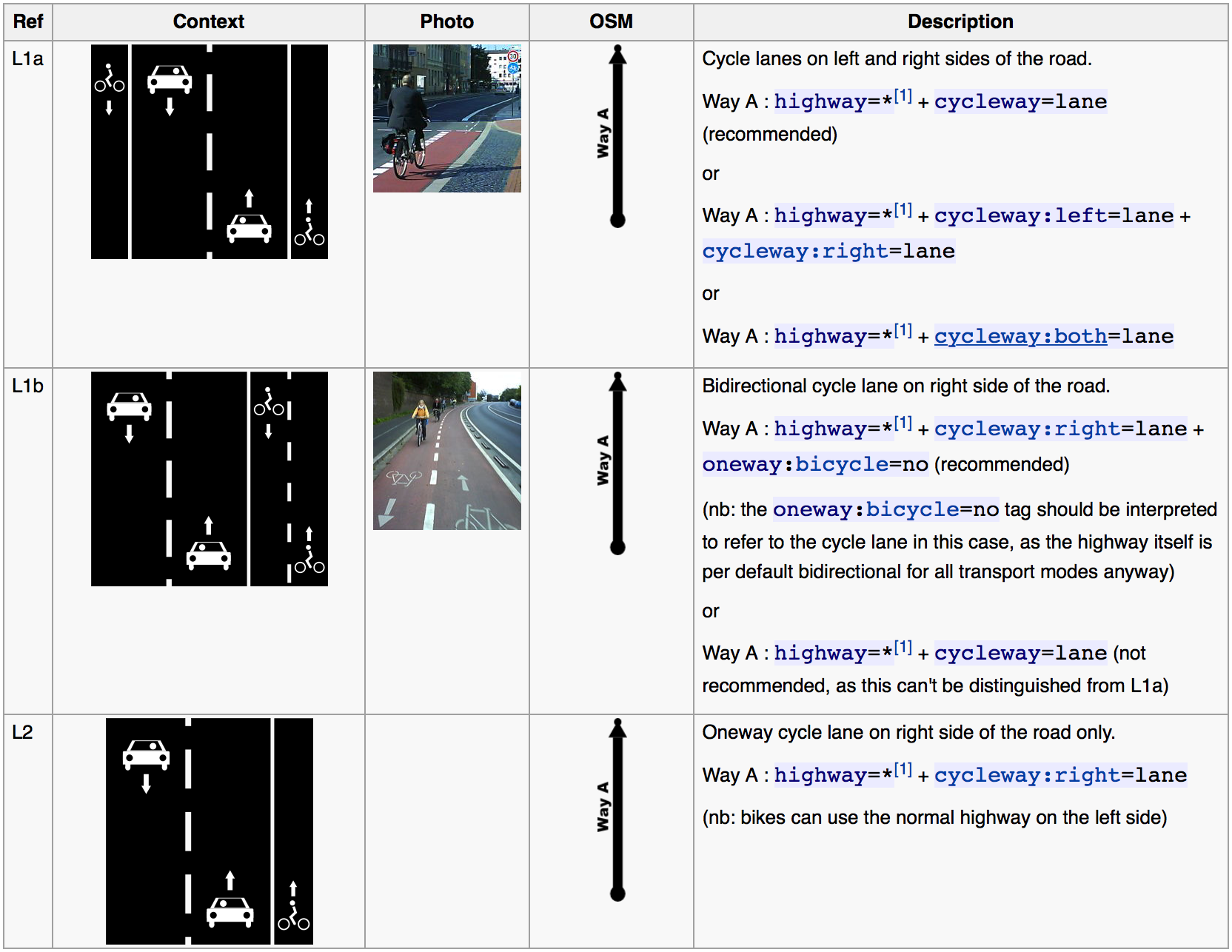 image via OSM wiki
Who else is rolling down the bike path with you? Are electric bikes allowed? Be sure to check local laws. California just passed a new law outlining when it is permissible to operate an electric bicycle in bicycle lanes.
Points of Interest for Cyclists
You are ready to ride, but you don’t even have a bike! Lots of lucky city dwellers have bicycle share systems. San Francisco has the Bay Area Bike Share. 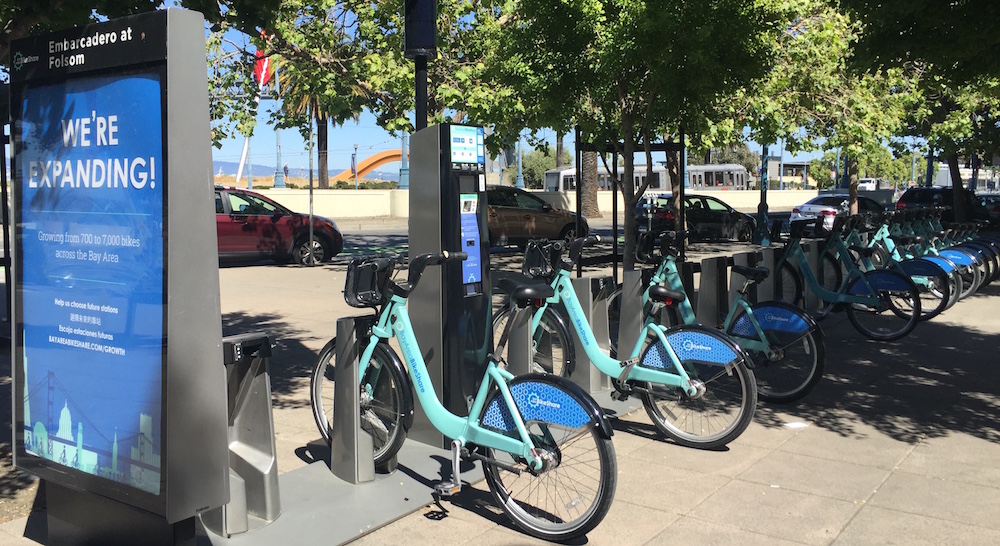 image via the author
Chicago area residents have Divvy, Paris has Vélib’ and Santander Cycles is well known in London.
What bike share operators do you have in your city, and can they be added to OpenStreetMap? Of course! Just remember that OpenStreetMap is comprised of local knowledge and truly open data, so feel free to add the locations you are personally familiar with. Express permission to use the bike station maps provided by these operators must be obtained before using them to add features to OpenStreetMap. When this permission is granted, be sure to include a source=* key with your edits.
The table above aggregates several types of bicycle points of interest, but if we focus on just bicycle share and rental systems, you’ll see how often they make up the bulk of the points. Paris sure does have an impressive number of bike share locations in OpenStreetMap - nearly 1,300. For context, the Vélib’ bike share company in Paris boasts 1,800 stations on their website (as of May, 2016). That puts OpenStreetMap at roughly 70% coverage. Truly impressive!
Now you are riding along and suddenly you get a flat tire, or your brakes need adjusting, or maybe it’s the derailleur this time. Perhaps you have all the tools with you, but if not, you’ll be happy to find a bike shop or a bike repair station. I just recently saw a bike repair station next to a multi use path, but I can’t remember where for the life of me. If only I had added it to OpenStreetMap right when I saw it…
amenity=bicycle_repair_station
You’ve reached your destination and what is the first thing you look for? Did you say “a safe place to park and lock up your bike”? Sometimes you can just lock your bike up to any immoveable structure. This is definitely NOT the case on most school campuses! Let’s add designated parking for bikes:
Road Based Characteristics
Sometimes the rules of the road also influence the comfort of the ride for cyclists. Pedalling alongside fast moving traffic can be terrifying if you are not an experienced rider with nerves of steel. Routes can be tailored for cyclists based on experience. A route generated for a less experienced bicycle rider might avoid busier secondary roads and favor residential roads, or simply favor roads that have lower speed limits for vehicle traffic.
Bicycle routes can also be customized based on the type of bike you have. If you have a road bike, routes can be restricted to roads that are paved. If you have a mountain bike, this restriction may not apply. The surface tag stores this information.
highway=*
primary
secondary
tertiary
residential
Where to Start
The best place to start is always where you have local knowledge. If you are familiar with a bicycle infrastructure that isn’t tagged properly in OpenStreetMap, now is your chance to remedy the situation!
Interactive Map
Would it be helpful to see where bicycling infrastructure exists in OpenStreetMap? There’s a map for that! This simple map allows you to enter in a start and end point and generate a bicycle route. Further refine the route by dragging the start and end icons.
This map is interactive! Open full screen ➹
Check out bike infrastructure in Paris, Copenhagen, London, Shanghai and more!
Custom symbology derived from the underlying OpenStreetMap tags has been employed to help identify how features are currently represented in the data. We are hoping that the labels, line, and color choices will help you recognize bike infrastructure and identify whether or not it is tagged properly. Special thanks to Nathaniel V. Kelso for building this special map style for this blog post!
The map above uses Mapzen Search, Turn-by-Turn Routing, TransitLand for public transit, and Tangram to display routes generated for drivers, pedestrians, public transportation users and cyclists. You can build amazing things with these services, too! Head over to our developer page to sign up for API keys.
What can you do if you plug in a route with any of the solutions above and get a route that doesn’t quite fit with your local knowledge of the area?
Your best bet is to jump right in to OpenStreetMap and investigate the data to see where a tag might be missing or where a connectivity issue may exists.
To edit features, hover over bike infrastructure or bike points of interest in the map for this post to bring up an info bubble with links to editing tools that can be used to modify features.
Is something missing all together? Shift-click the map to launch the iD editor for OpenStreetMap at that location. You may not have control over how the software generates the route, but you always have the ability to investigate the data and pass on feedback to developers when the data seems sound.
Getting Started with OpenStreetMap
Need instructions on how to edit with iD? Here are some links to outstanding tutorials from LearnOSM, the OpenStreetMap wiki, and the United States Department of State’s Humanitarian Information Unit:
Are you a mapping wiz and interested in a more advanced editor? Try out JOSM with excellent documentation from Mapbox.
Editing with a Mobile Device
For those bike stores and other points of interest, I bet you are interested in a mobile app to edit OpenStreetMap while you are on the go.
iOS users can check out Go Map!! by Bryce Cogswell. This free editor allows you to add features and edit existing features. Check out the Go Map!! wiki page for more details. Pushpin by Fulcrum is another excellent iOS editor for OpenStreetMap points of interest.
Looking for an Android equivalent? Vespucci by Marcus Wolschon is a great option. Check out the Vespucci home page for documentation and tutorials.
Last but not least, for both iOS and Android, MAPS.ME now supports editing.
Get outside, increase your local knowledge, and share it with the world through your OpenStreetMap edits!
Check out all the posts in the Targeted Editing series:
